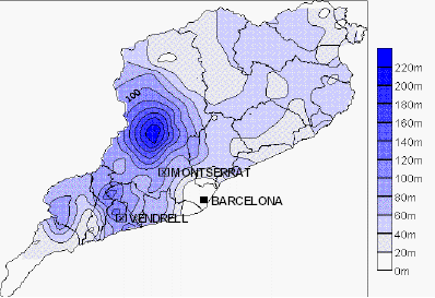
An isopleth map generalizes and simplifies data with a continuous distribution. Isopleth maps show the data as a third dimension on a map, thus isopleth maps are an umbrella term for mapping surface elevations, amounts of precipitation and atmospheric pressure readings. The third dimension is shown by a series of lines called isopleths which connect points of equal value. Isopleths never cross or divide and always form enclosed circles inside the map. The image shown above is that of the concentration of precipitation in Italy 10th of June 2000.
No comments:
Post a Comment