Tuesday, July 29, 2014

Star Plot


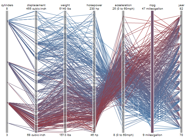
A star plot is a method of studying multivariate data where each star is one unique observation. Each star contains a set amount of variables that are studied for the whole set of stars. Each variable has a range that each star uses to record specific data used to compare with the rest of the stars. Star plots can compare a large amount of objects with a large number of the same variables. The image above is an example of a star plot that shows a set of sixteen stars that each share the same nine variables which can be compared at a glance that can show the particular advantages and disadvantages each car has in comparison to one another.

Correlation Matrix


(Table 8.1 near bottom of page)

A correlation matrix describes a correlation among matrix variables. It's basically a table that contains correlation coefficients. The original variables can be directly computed, but I personally do not know how to explain how to compute this nor how to explain how to calculate it. The image above is an example of a correlation matrix of economic variables that are correlated together in simplified mathematics after very complex calculating (when seeing how complex each variable is) and averaging each principal variable. 

Similarity Matrix

(bottom page)

A similarity matrix is a matrix of scores that represent the similarity between a number of data points. Similarity matrices are used to find data points found in clusters. Also, similarity matrices can be used to align sequences of DNA. Similarity matrices can be used to organize similarity between objects so that all the objects are compared with each other and can thus show the similarity within the table. The image shown above is an example of a similarity matrix where every individual is compared with the other from Charley to Ron on their baseball skill ratings.

Stem and Leaf Plot


Stem and leaf plots are devices for presenting quantitative data in a graphical format to visualize the shape of a distribution in a number set. Stem-and-leaf plots retain the original data to at least two significant digits, and put the data in order. Stem and leaf plots make it easy to find the mean, median, mode and range rather quickly due to all the data points being made available. The image shown above is an example of a stem and leaf plot where a large group of numbers are easily organized to show order in a disorganized set of number of boxes bought.

Box Plot

(bottom of source page)

A box plot is graphical way of depicting groups of numerical data through their group quartiles with basic statistical concepts like mean, median range and mode. A box plot may have lines extending vertically from the boxes, the "whiskers" which indicates variability outside the upper and lower quartiles. Box plots display variation in samples of a statistical population without having any assumptions of the statistical distribution. The spacing between the different parts of the box indicate the degree of dispersion and degree of skew in the data, while also showing outliers. Box plots can be drawn either horizontally or vertically. The image above is an example of a box plot of daily mean temperature in Fahrenheit for November 1940, Madison, Wisconsin.

Histogram


A histogram is a graphical representation of frequency within a distribution of data. Histograms are effective when talking about the totality of something to find out where frequencies may occur. Histograms are important to use to find out patterns that may exist and expose outliers that may have previously been difficult to pinpoint. The image shown above is an example of a histogram that exposes that the most frequent amount of Greek tragedies is between 7,000 words and 8,000 words. 

Parallel Coordinate Graph

(mid-top of source page)

A parallel coordinate graph is a common way of visualizing complex high-dimensional geometry and multivariate data in a much less complex graph. Parallel coordinate graphs are difficult to construct due to the scaling of the axes, the ordering of the variables, and rotation of the axes.  Parallel coordinate graphs can easily be inaccurately made as well as inaccurately read which is why it is not popularly used outside of research fields that test products and use parallel coordinate graphs often. Parallel coordinate graphs compare two variables on a set of characteristics with multiple tests. Both variables are usually distinguished with a different color. The image shown above is an example of a parallel graph that compares two vehicles with a large sample size of tests.

Triangular Plot


A triangular plot is a barycentric plot where three variables of a certain end product are composed of a percent of each of the three variables. Triangular plots are read from the X variable up, the Y variable corner to the right and the Z variable from the right corner to the left side. The end product is a 100% composition added together from the three variables. Triangular plots ignore quartnery and other extraneous variables that were negligible so that the triangular plot can remain easily read.  The image shown above is an example of a triangular plot where types of soil can be named determined by the amount of the soil that is composed of clay, silt and sand.


Wind Rose


A wind rose, is a graphic tool that gives a clear view of direction and wind speed distributed at a particular location. The cardinal directions of north, east, south and west are used to organize the total amount of wind shown. A wind rose is basically a pie chart where each slice represents the distribution of wind speed and direction. The wind speed class key organizes the wind speed so it can be easily understood. The image shown above is an example of a wind rose for ALLIANCEWEST automated weather data network stations throughout Nebraska from 1996-2005 where most of the wind went in the western direction.  

Climograph


A climograph shows the trend of precipitation and temperature with the progression of time, inches of precipitation occurring and degrees of temperature shown on the X and Y axes. Usually the time scale occurs over a year where precipitation is correlated with temperature. Also climographs can be useful to compare different locations as well as make it easy to see extreme weather events occurring for a particular year for the same location. The image above is an example of a climograph in Boulder, Colorado that shows a relatively weak positive correlation between precipitation and temperature.

Population Profile


A population profile breaks down a country's population with age intervals, male and female distinctions, and shows the amount of people within each interval. Population trends can typically be seen when a population profile is used to show either an unchanging population, an exploding young population or an aging population. On a population profile an unchanging population looks like a rectangle, an exploding young population looks like a pyramid and an aging population looks like an upside down pyramid. The image shown above is an example of the District of Columbia having had an exploding young population twenty years ago where now it is slowly becoming an  upside down pyramid.  

Scatterplot


(scatex.gif on the list)

A scatterplot is a type of diagram that displays data on a graph that plots individual data points with the X axis and Y axis. A certain set of patterns can be displayed when all the data points are plotted. If all the points are plotted across the graph with no discernible pattern then there no correlating pattern among the points. If all the points follow closely together from the bottom left of the map to the top right then it shows a strong positive correlation while if all the points are close together starting from the top left towards the bottom right then there's a strong negative correlation. Weak positive and negative correlations are similar to graphs with no correlation where if the points weren't following a strict diagonal direction then there'd be no correlation between the points. The image shown above is a scatterplot that shows a strong positive correlation between the price of diamonds in carats and size of diamonds in carats.

Index Value Plot


An index value plot shows data in relation to a certain index value. The graph doesn't start at zero because the index value is used as the baseline to reference the value along the graph. The index value plot is used because it easily distinguishes when the plotted values go above or below the index value. The image shown above is an example of an index value plot that shows the I.S.M. Non-Manufacturing Index from 1997-2009 with the index value of 50 where the plotted value can be observed to go below the index value during times of recession.

Lorenz Curve Graph


(mid-page)

A Lorenz curve graph shows the actual curve that represents real data from observations that occur in a geometric sequence and an ideal line which occurs in an arithmetic sequence created to show the disparity between the actual curve and the ideal line. Both lines are shown so that disparity can be seen from the idealized line to the actual curve of a specific country at a specific time. The image above is an example of a Lorenz curve graph for South Africa which shows perfect equality as the idealized arithmetic sequence line while the actual percent income curve is represented as the geometric sequence curve. 

Bilateral Graph


A bilateral graph shows two correlated data sets on one graph. A bilateral graph uses the same X axis and Y axis to organize both data sets so they can be compared easily. Each data set has a differentiating factor like a different color as well as a key to distinguish both data sets. They be similar data, but they are independent of each other while graphed. The image shown above is a bilateral graph effectively comparing the value of the Australian dollar.

Nominal Area Choropleth Map


A nominal area choropleth map describes the mapped area's non-categorical qualitative data. A nominal area choropleth map shows the accurate area of the area shown as well as the name of the area as well as any nearby bodies of water as well as latitude and longitudinal lines on the map. A nominal area choropleth map is a descriptive map that shows the agreed upon governmental boundaries on a country and its states. Nominal area choropleth maps do not show statistics, just the qualitative data of the area simplified so it can be shown easily as a reference. The image shown above is a nominal area choropleth map of Africa that gives a qualitative view of Africa without any quantitative data to cover the mapped area.

Unstandardized Choropleth Map


An unstandardized choropleth map is similar to other types of choropleth maps except that the class key used in unstandardized choropleth map uses assymetrically specific numbers that fit with the map area represented. The unstandardized choropleth map allows for much more accuracy and pragmatism as well as allows the cartographer more freedom to narrow the ranges to fit their purpose. The image shown above is an example of an unstandardized choropleth map where you can witness the cartographer using specific ranges unique to Sao Paulo's total population and population density in 1991.

Standardized Choropleth Map


A standardized choropleth map utilizes state and country boundaries to delineate and separate areas. County areas then have their own saturated color separate from the country. All countries can use standardized choropleth maps because all countries have a type of governmental subdivision similar to counties that have their own representative data unique to themselves. Counties next to each other may have the same color, but it doesn't mean they have the same data. Standardized choropleth maps are simple to read and can help make governmental decisions as well as educate the public about their own county and country statistics overall. The image above is an example of a standardized choropleth map that utilizes county and country boundaries to distinguish data for Canada separated from the United States.  


Univariate Choropleth Map


A univariate choropleth map shows statistical data aggregated over predefined regions with coloring or shading of these regions. Univariate choropleth maps assume a relatively even distribution of the measured phenomenon within each region. Depending on the map data of the univariate choropleth map there are differences in hue to indicate qualitative differences while differences in saturation or lightness are used to indicate quantitative differences. The image shown above is of a univariate choropleth map showing water usage across the United States where extensive use of water was shown by blue color saturation.


Bivariate Choropleth Map


A bivariate choropleth map displays two variables on a single map by combining two different sets of graphic symbols or colors simultaneously. The main objective of a bivariate choropleth map is to find a simple method for accurately and graphically illustrating the relationship between two spatially distributed variables. Bivariate choropleth maps have potential to reveal relationships between variables more effectively than a side-by-side comparison of the univariate maps. Bivariate mapping is a recent graphical method which is intended to convey the spatial distribution of two variables and the geographical concentration of their relationship. The image shown above is an example of a bivariate choropleth map that combines to show what percentage of the population is under eighteen as well as those that live in rural areas in Poland.

Unclassed Choropleth Map

(middle of page)

An unclassed choropleth map is useful to show data for a country overall without getting into specific counties or states. An unclassed choropleth map does not deal with averaging out data to a certain amount of classes so it uses a continuous tone scheme to represent data in a blotchy amorphous way. Unclassed choropleth maps are not restricted with boundaries so that there is an accurate yet unorganized general view of how data is represented for a region. The image shown above is an example of an unclassed choropleth map where the continuous tone scheme represents concentrations of women who are 50-64 years old have more than three children over the country as a whole.

Classed Choropleth Map


A classed choropleth map uses shading and other techniques to represent data in groups or classes. A classed choropleth map usually uses a mono-color light to dark technique where the lighter shade represents less of the target data and darker shades of the color represent more of the targeted data in the specific area. Classed choropleth maps are usually shown to represent survey data and census information.The image shown above is a classed choropleth map that has six classes and classifies the counties in Australia by deaths per one thousand live births. 

Range Graded Proportional Circle Map

(bottom of page)

A range graded proportional circle map is a type of symbol map that utilizes a circle size within a certain range of data. Point data is mapped with a circle instead of a dot, and there are a finite or set number of sizes used for the circles. A range graded proportional circle map is used when the the map makers want to show an average to fit with a set number of circles. The map shown above is an example of a range graded proportional circle map of internet users in 2004 in western Europe.

Monday, July 28, 2014

Continuously Variable Proportional Circle Map


A continuously variable proportional circle map shows proportional circles that come in a wide distribution of sizes that are not limited to classes. There are no set amount of classes in a map key that limit the size of the proportional circle hence the map being called a "continuously variable proportional circle". Continuously variable proportional circle maps can express all data in the map more accurately for each individual area than averaging it out to a set number of proportional circles. The image shown above is of a continuously variable proportional circle map that shows the proportion of different types of meat that were sent to Paris butcheries from different regions in France.

Digital Orthophoto Quarter Quadrangle


The Digital Orthophoto quarter Quadrangle or (D.O.Q.Q.) covers a quarter of the Digital Orthophoto Quadrangle which is aerial photography or satellite imagery that has been edited so that its pixels are aligned with longitude and latitude lines for organizational purposes and have a narrowly defined region of coverage. The Digital Orthophoto quarter Quadrangle is a widely used format introduced by the United States Geological Survey. D.O.Q.s produced by the U.S.G.S. cover an area measuring 7.5-minutes longitude by 7.5-minutes latitude. Digital Orthophoto Quarter Quadrangle covers one quarter of a quadrangle which shows more detail than the standard D.O.Q. The image above is from 2005 of  the Digital Orthophoto quarter Quadrangle from Cole County, Illinois.

Digital Elevation Model


A digital elevation model or D.E.M. is a three dimensional representation of a terrain's surface which can include non-terrestrial surfaces like the moon. D.E.M. data is mostly received from satellites. Multiple satellites coordinate and perform stereo and tri-stereo operations for accurate elevation readings. Stereo satellite operations use two satellites to create D.E.M.s when there is no large change in elevation heights whereas tri-stereo operations use three satellites that can accurately show data between areas where there is a large change in elevation height. Private companies as well as governmental satellites can provide this type of imaging which vary in image quality and resolution. The image shown above is a digital elevation model of a small part of Indiana where you can distinguish the ridge lines that could form a river from the rest of the landscape which is at a higher elevation. 

Digital Line Graph


A D.L.G. or digital line graph is a cartographic map feature represented in digital vector form that was created by the United States Geological Survey. D.L.G.s are collected from U.S.G.S. maps and are distributed in large, intermediate and small-scale with different categories of features depending on the scale. The D.L.G. features national park boundaries, public land section lines, hydrographic features, topographic contour lines, Roads, trails, and railroads. D.L.G.s are a soft copy overlay which allowed features to be optional and modified to what the user requires. The image above is a D.L.G. on a U.S.G.S. map section where you can individually distinguish roads, hydrographic features as well as topographic contour lines.


Digital Raster Graphic


Digital Raster Graphics or (D.R.G.s) are scanned, digitized and georeferenced United States Geologic Survey topographic maps. They can be found in three scales that are available from 1:24,000 to 1:100,00 and 1:250,000 scales. The datum of the source materials is preserved in the D.R.G. The U.S.G.S. uses up to 13 colors on each D.R.G. map and has high quality versions available. U.S.G.S. D.R.G. maps as well as other map types of the U.S.G.S. are widely available online as well as hard copy versions are available if you look for them at a local university or book store. The image above is a D.R.G. of a section of the U.S.G.S. in Yosemite National Park. Landmarks are shown on the D.R.G. as well as elevation lines that would be helpful for anyone temporarily camping and hiking in Yosemite National Park.

Isopleth Map


http://geographyfieldwork.com/DataPresentationMappingTechniques.htm

An isopleth map generalizes and simplifies data with a continuous distribution. Isopleth maps show the data as a third dimension on a map, thus isopleth maps are an umbrella term for mapping surface elevations, amounts of precipitation and atmospheric pressure readings. The third dimension is shown by a series of lines called isopleths which connect points of equal value. Isopleths never cross or divide and always form enclosed circles inside the map. The image shown above is that of the concentration of precipitation in Italy 10th of June 2000.

Isopach Map


http://www.geo.utexas.edu/faculty/barker/kempter/rbtephra.html

An isopach map illustrates thickness variations within rock layers or stratum. Isopachs are contour lines that represent equal thickness over an area. Isopach maps are utilized in hydrographic survey, stratigraphy, sedimentology, structural geology, petroleum geology and volcanology. Isopach maps can help protect lives as well as save money when used in certain geologic fields. The image shown above shows the value of having an isopach map. This isopach map shows the dispersal of ash that could be potentially harmful to those living nearby the estimated area.

Isohyetal Map

(Click Agree no worries, middle of page)

An isohyetal map is map that simply shows isohyet lines that represent the amount of rainfall in an area. Isohyet lines that are close together show large differences in the amount of rainfall whereas isohyet lines that are far apart show much less change in the amount of rainfall across an area. The image shown ago is that of an isohyetal map of the island of Kaua'i where isohyet lines are spaced out in  low elevation areas in contrast to areas of high elevation that have a much larger amount of rainfall as well as a larger change in the amount of rainfall the higher the elevation becomes. 

Isotach Map

(middle of page)

Isotachs maps have lines on weather maps that connect points where winds of equal speeds have been recorded. These maps can show patterns of where the wind is going and how far a particular system is progressing across a part of the United States. When the isotach lines are close together it shows a larger magnitude in the gradient of  wind speed for that area. The image shown above is a snap shot of the status of a wind system of the northeastern continental shelf of the United States and it also can be extrapolated that the high speed wind system is moving south from the majority of the map.

Isobars on Surface Map


Isobars on a surface map is a map that has lines of equal atmospheric pressure drawn on a meteorological map. Each line passes through a pressure of a given value given that isobar lines may never cross or touch. Isobar lines may only pass through pressures of 1000 millibars, give or take four millibars. Pressure lines are usually corrected by the sea level height standard so any differences in pressure due to altitude can be ignored since altitude can change drastically along the United States. The image shown above is a surface map with isobars that depict areas of high pressure and low pressure with isobar lines. Spaced out isobar lines indicate negligible pressure changes while areas with isobars that were close together indicates a large change in pressure. 

LIDAR


http://grass.osgeo.org/screenshots/

LIDAR is a remote sensing technology that measures distance by illuminating a target with a laser and analyzing the reflected light. The word LIDAR is not a acronym, it's a portmanteau of (li) from "light" and (dar) from "radar". LIDAR is used to make high-resolution maps of the surface of the earth. LIDAR provides three dimensional information that allow scientists and mapping professionals to examine both natural and manmade environments with accuracy, precision, and flexibility. There are two types of LIDAR, topographic and bathymetric. Topographic LIDAR uses a near-infrared laser to map the land, while bathymetric LIDAR uses water-penetrating green light to measure seafloor and riverbed elevations.The lidar image above shows a dune migration at Jockey's Ridge State Park, North Carolina where you distinguish different types of land features by the color they emit.

Doppler Radar


http://4warnwxteam.com/2011/04/26/a-brief-explanation-of-how-doppler-radar-works/

Doppler radar is a specialized type of radar that utilizes the Doppler effect by radiating pulse emissions so that accurate weather forecasts can be imaged. Doppler radar creates images at a time lapse radiating from the weather station that houses the doppler radar facility. Doppler radar usually locates precipitation as well as the intensity of the precipitation. The doppler radar image is understood by the color class that depicts light precipitation with the light blue color to heavy precipitation with dark red coloring. The image shown above is a doppler radar image frame from the National Weather Service that depicts a hurricane over Texas from a doppler radar station near Houston.

Black & White Aerial Photography

(middle of the page Austin, Texas image link)

Black and white aerial photography is a map type solely concerned with giving a detailed overhead snap shot of what the land looks like. Black and white aerial photography is used primarily by cartographers and city planners that use detailed measurements from aerial photography to prepare maps as well as using aerial photos as a barometer to determine land use and environmental conditions. The black and white aerial photo shown above is of Austin, Texas that provides a high quality detailed snap shot of the area that can be referenced by the local government, private companies and educational institutions.

Infrared Aerial Photography


http://pie-lter.ecosystems.mbl.edu/content/research-locations-maps-and-aerial-imagery
(2nd to last link on the web page)

Infrared aerial photography is a type of map created by satellites and high-altitude aircraft that give engineers and scientists the data to study landforms, vegetation health patterns and environmental pollution on the planet's surface by viewing the differences with "color". Satellites and high-altitude aircraft are equipped to record scenes of the Earth where light is shown on both the visible and invisible parts of the electromagnetic spectrum. Near-infrared light is invisible to the human eye, but adding this light to these images allows scientists to "see" the surface of the Earth in other than natural colors. The infrared aerial photo shown above shows the mouth of the Parker River and northern Plum Island Sound, Newbury, Massachusetts which shows a lot of material at the mouth of the stream that eventually lessens in intensity as the stream continues further on.

Cartographic Animation

(Bottom of page Ctrl+F "NOAA")
http://www.payer.de/thailandchronik/chronik2004c.htm

Cartographic animation is the application of animation to add a temporal component to a map displaying change in some dimension. Change over time is commonly used where depending on how many of frames  can depict change over a period of time. The .gif animation shown above is a cartographic animation of the tsunami that started near Indonesia in 2004 and fanned out. This animation is quick yet shows phenomena that happens in a much longer time scale of hours and days. The animation is easy to understand and repeats so that you can look at different parts of the map when the animation resets. This particular cartographic animation is clean because the animation contains a large amount of frames per second which indicates there was a lot of cartographic data to work with in contrast to other cartographic animations that have a few frames and would resemble a slide show.

Statistical Map


http://www.mappery.com/map-of/United-States-Travel-Time-to-Work-Statistical-Map

A statistical map is a type of map that indicates the variation in quantity of the variable in a geographic area. "Statistical map" is an encompassing umbrella term for maps that use statistics such as numerical maps, choropleth maps, contour maps, isopleth maps, dot maps, proportional circle maps, symbol maps, pie chart maps, and histogram maps. The statistical map shown above shows mean commuter time to work from 2003 which is averaged for every state and shows statistical variable differences easily with the class key on the bottom right of the map.

Cartogram


http://www.spatialanalysis.ca/2011/exploring-germany-through-cartograms/

A cartogram is a type of map in which some type of thematic variable is visually substituted for distance or land area. The space within the map is purposefully distorted in order to visually show the intensity of the thematic variable. Cartograms help to show concentration of populations spread over land masses so that the general viewer can observe concentration accurately for when the size of a seemingly tiny piece of land is much more heavily populated and must not be ignored or deemed statistically insignificant. The map shown above shows a side by side comparison of a choropleth map of population with that of a cartogram to exacerbate the importance of the distribution of the German population in city centers.

Flow Map


(Texas - Truck Freight Flow Map (Combined Domestic and International), 1998 (U.S. Federal Highway Administration)) <- click this on the list)

A Flow map is a mixture of a map and flow charts that show the movement of objects from one location to another. Flow maps are utilized to show movement of almost anything from weather to commercial products. Flow maps indicate flow of the variable, the direction of this flow, the source of this flow and the destination of this flow. The thickness of the flow line depicts how much of the variable is being depicted.  Flow maps are very simplified and generalized as they show little else than the flow paths from one point to another. The flow map shown above shows the combined truck flow from Texas. The map shows little else, but doesn't have to because it effectively shows the combined truck flow throughout the United States.

Isoline Map

(bottom middle hyperlink)
http://www.d.umn.edu/~brant055/catalogue%203532.html

An isoline map describes distributions of a particular variable on a map. An isoline map shows continuous lines joining points of equal value. It is difficult to describe what an isoline map with an example because an isoline map depicts an umbrella of phenomena where specific map types fall under isoline maps. The example of an isoline map above is of suspended dust particles greater than .01 grams per liter of air. I'm not sure if it's an example of an isoline map because it contains similarities to isobar maps, isotachs, isohyets, isopachs and isopleth maps. A map of suspended dust particles is not a map type in it of itself so I think it can be used as a generalized isoline map where lines exist to connect equal amounts of dust in the air across the map.


Proportional Circle Map

(Graduated Circle Map image bottom middle)
http://personal.frostburg.edu/sbriggs0/maps.htm

Proportional circle maps scale the size of circles proportionally to the data value found at that particular location. They simply show that the larger the symbol equals more of the statistical value at a certain location. Proportional circle maps can easily conveys information when the circles are classed and that a key exists somewhere on the map. A proportional circle map without a class key can be confusing and misrepresent the data when the circles have common shapes. The proportional circle map shown above is of Walmart store locations in the United States which has a class key. Information is effectively expressed because the circles vary in size and are shown in an effective range that can be used on the United States size map.

Choropleth Map

(bottom of page)
http://www.geog.ucsb.edu/~jeff/gis/choropleth_maps.html

A choropleth map shows areas by shading or patterning in proportion to the measurement of the statistical variable being displayed on the map. Common choropleth maps use statistical variables like population density or per-capita income. A choropleth map is a simple map type that depicts an average via a graded scale. The choropleth map provides an easy way to visualize how data varies across a geographic area or it shows the level of variability within a region or multiple regions. The choropleth map above is of crime rates in the U.S. overlayed with election results from 2004 above via colored shading.

Dot Distribution Map


A dot distribution map is a map type that uses the dot symbol to depict phenomena across space. The location of the dots can depict spatial patterns when grouped together. A dot distribution map can shown the spread of disease as well as what language is spoken in an area. An advantage of dot distribution maps is that it can easily depict ideas by removing irrelevant detail. A disadvantage of dot distribution maps is that the dot size and spacing can inaccurately depict information depending on how well the map is made. The dot distribution map shown above depicts the advantage and disadvantage of their use. The map easily shows global populations, but also makes it difficult to depict the amount of dots that are shown because the most populated land areas turn the dots almost turn into a type of shading.  


Propaganda Map


A propaganda map is a map with the goal of visualizing propaganda to a world map scale as well as smaller scales. Propaganda maps have the goal of persuasion to depict an outside group as evil and as the group in power as a force for good defending the country. Propaganda maps can be shown as true and false depending on the detail and imagery shown to depict themes of politics, economics and social problems. Propaganda maps are subjective products that market a one sided view of spatial knowledge. Propaganda maps are used because they are widely successful maps that can distort reality in order to sway individuals who share an opposing political view. The propaganda map shown above depicts Russia as a force of good that should expand because it's growing towards several smaller countries that would benefit in becoming part of Russia.

Hypsometric Map

(bottom of page)
http://www.acsu.buffalo.edu/~dbertuca/maps/cat/map-portion-images.html

Hypsometric maps or also known as hypsometric tinting use colors to indicate elevation as well as contour lines. They can be used to depict ranges of elevation as bands of color, usually in a graduated pattern or rainbow applied to contour lines themselves. A typical hypsometric map progresses from dark green to lower elevations to yellows and then to white at the highest elevations. Hypsometric maps of land is often accompanied by a similar method of bathymetric tinting to convey the depth of oceans to complete a global hypsometric map. The hypsometric map shown above is not in English, but I can understand it because it has all the features of a hypsometric map where I can understand that the middle of the map is the lowest elevation shown whereas the southwest section of the map is the highest elevation due to the key depicting the graduated color scheme.

Public Land Survey System Map


(mid-bottom of page)
A Public Land Survey System map is a map that shows the subdivision and description of land in the United States after the Revolutionary War in the western part of present day United States of America. All lands in the public domain are altered to fit within this rectangular system of surveys. The Public Land Survey System is a rectangular survey system that divides the land into 6-mile square townships which are further subdivided into 1-mile square sections. This system graphs land so that you can find land easily when each section has their own unique identification. The Public Land Survey System map used above shows the rectangular system in action representing Franklin County in Alabama. 

Sunday, July 27, 2014

Cadastral Map


https://www.tasmap.tas.gov.au/do/product/5438
(click View Sample Image)

A cadastral map, is a comprehensive view of the metes-and-bounds system used on an area of land. A cadastral map shows details of the ownership, the tenure, the precise location, dimensions and the value of individual parcels of land. Most countries use cadastral maps for administrative and legal purposes to define as best as possible the dimensions and location of land parcels which are very useful to settle law suits and land disputes between neighboring land owners. The image above is that of a cadastral map in Australia that depicts parcels of land available for sale sectioned off into what I believe to be in polygonal sections that are measured in acres of land.


Thematic Map

(top-middle of page)
http://udel.edu/~csiwinsk/frec480/proj1/

A thematic map is a type of map or chart especially designed to show a particular theme connected with a specific geographic area. These maps inter-relate aspects of land use with complicated issues concerning politics, culture, and the physical environment. A thematic map is able to tell a story of what is occurring in an area in relation to human activity. The image above is a thematic map that tells a story of poverty within America where poverty  is shown to occur in the southern and northwestern parts of the United States.